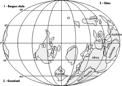
Take a careful look at this world map and get dis-oriented! Does China (3) lie due north of Africa? Is China really that small! Why is Africa northeast of Europe, and since when is Europe way below the equator, two-thirds of the way to the South Pole?
According to current interpretations of the paleogeographic record this is how the continental blocks were arranged about one-half billion years ago - before plate tectonics (still an active process!) rearranged them into today's familiar pattern. Several numbered sites on this map show some of the areas where Burgess Shale-type fossils have been found.
In the center of this reconstruction, the North American continental block is turned 90 degrees clockwise, lying close to the equator. While it is not shown here, much of its central portion lies under water, flooded by the immense, inland Sauk Sea (named after Sauk Center, Minnesota, an ancient shore area). Parts of what will become Eastern Canada and New England are still stuck onto part of Europe to the south, while South America is still nestled against Africa.
Because of North America's location, the sea shores at the Burgess Shale site in Canada are warm and tropical. Coral reefs are common. Later, the separate continental parts shown here will move together, and during the Paleozoic era the Permian period will form one huge landmass - Pangaea. That, in turn, during the Mesozoic will break into two masses, Laurasia and Gondwanaland. Still later, about 100-140 million years ago, when the mid-Atlantic rift becomes active, the North American plate and Europe will be shoved apart. On the other side of our continent, the Pacific plate will be shoved into and under our west coast. When that plate moves toward and sinks under the North American continental block, it will carry along various chunks of off-continental fragments to be scraped and "plastered" against the western coastal regions as the plate sinks beneath. When this land is added to the coast, it will push the Burgess Shale location even further from the sea. (Now, it's about 400 miles inland.) Simultaneously, when the Pacific plate sinks beneath the coast, its (lighter) added bulk will "float" the Burgess Shale site miles high to its present location.
Return to Burgess Shale Page